
-
Two confirmed dead, about 20 still missing in Shizuoka mudslide as heavy rain hits Japan

Two people died and about 20 others remain missing after torrential rain triggered a large mudslide southwest of Tokyo on Saturday, destroying more than 10 houses, local authorities said.
A video posted on Twitter showed black water mixed with soil and sand flowing rapidly from the top of a mountain — making a rumbling sound — at about 10:30 a.m. in Atami, Shizuoka Prefecture.
"I've lived here for about 60 years but this is my first (such) experience," said 70-year-old Masaru Isei, who lives about 50 meters from where the mudslide occurred.
Isei heard what sounded like heavy rain at around 10:45 a.m. When he opened a window on the second floor of his house he saw that his storage shed had been swept away and that a car in the parking lot was sinking into the ground. He then evacuated with his wife to an acquaintance's house located on higher ground, taking only his smartphone and wallet.
An 84-year-old man first noticed a rotting smell. When he looked upstream of a nearby river, he saw a huge amount of soil and sand about 5 meters high moving toward him.
The river, usually less than 2 meters wide, was overflowing with the mixture and had swollen to several dozen meters wide, he said.
The speed of the mudslide is estimated to have been around 40 kilometers per hour, said Motoyuki Ushiyama, a professor at the Shizuoka University Center for Integrated Research and Education of Natural Hazards.
The site is in a sediment disaster warning area, Ushiyama said. It had been raining heavily in Shizuoka for some time.
Fumitoshi Imaizumi, a professor of erosion control engineering at Shizuoka University, said the area is prone to mudslides due to volcanic sediment accumulating on slopes.
"The total amount of rainfall in the area was quite heavy, so it created conditions for (mudslides) to occur."
About 200 homes had been left without power, an Atami city official said. The mudslide reached the nearby coast, according to police.
"I heard a horrible sound and saw a mudslide flowing downwards as rescue workers were urging people to evacuate. So I ran to higher ground," a leader of a temple near the disaster told NHK.
"When I returned, houses and cars that were in front of the temple were gone."
Around 21,000 households in Atami, home to hot spring resorts, were ordered to ensure their safety immediately as the city government issued the highest level of evacuation alert.
"Because of the heavy rain, the ground loosened and the mudslide occurred … it picked up speed and swept away houses together with people," Shizuoka Gov. Heita Kawakatsu told reporters.
Rescue workers are searching for those who remain missing. They also received about 10 calls from people who are trapped in their houses due to the mudslide.
The Ground Self-Defense Force dispatched around 30 members to the area in response to a request from the prefectural government.
Prime Minister Yoshihide Suga called an emergency meeting with members of his Cabinet in the evening, instructing them to work with local authorities to ascertain the scope of the damage and calling on the public to be ready to evacuate when necessary and "take action to protect your lives.": https://www.japantimes.co.jp/news/20...vy-rain-japan/Leave a comment:
-
^Still dangerous but some must be happy to know it slowed down to a Tropical Storm
Leave a comment:
-
Leave a comment:
-
Elsa becomes 1st hurricane of Atlantic season

Elsa strengthened into the first hurricane of the Atlantic season on Friday, as it slammed Barbados as a Category 1 storm and threatened other parts of the eastern Caribbean.
Why it matters: Elsa is the earliest fifth-named storm on record. The National Oceanic and Atmospheric Administration (NOAA) has predicted an above-average storm season in the Atlantic this year.
The big picture: A hurricane warning has been issued for St. Vincent and the Grenadines, St. Lucia and parts of Haiti, the National Hurricane Center said Friday morning.- A tropical storm warning was in effect for parts of the Dominican Republic, Barbados, Dominica, Jamaica and Martinique.
- Outer rain bands from the storm will impact Puerto Rico late Friday into Saturday, NOAA said, adding that flooding and mudslides are possible.
- NOAA said there is a "risk of storm surge, wind and rainfall impacts in the Florida Keys and portions of the Florida Peninsula early next week. However, the forecast uncertainty remains larger than usual."
Our thought bubble via Axios climate and energy reporter Andrew Freedman: Both the intensity and track forecast for Hurricane Elsa have a higher amount of uncertainty than we typically see at this time range.- How much the storm interacts with land, particularly the higher elevations of Hispaniola, may determine how strong the storm is if it directly affects Florida.
Leave a comment:
-
Tropical Storm Elsa Moving Quickly: Florida, Caribbean Should Track Forecast Closely

Tropical Storm Elsa is expected to barrel toward the Caribbean by Friday, where warnings have been issued for the Windward Islands. Residents of the Caribbean and Florida should track the progress of Elsa closely through the holiday weekend.
The National Hurricane Center (NHC) said Elsa was centered less than 400 miles east-southeast of the Windward Islands as of mid-Thursday evening.
New tropical storm watches have been issued for portions of Jamaica, the Dominican Republic and Haiti, which could see tropical storm conditions on Saturday.
Tropical storm warnings have been issued for parts of the Windward Islands, where tropical storm force conditions (winds of at least 39 mph) are expected on Friday. Those areas are shown in red on the map below.: https://weather.com/storms/hurricane...-united-states
Leave a comment:
-
Atlantic disturbance's chances of development jump to 60%
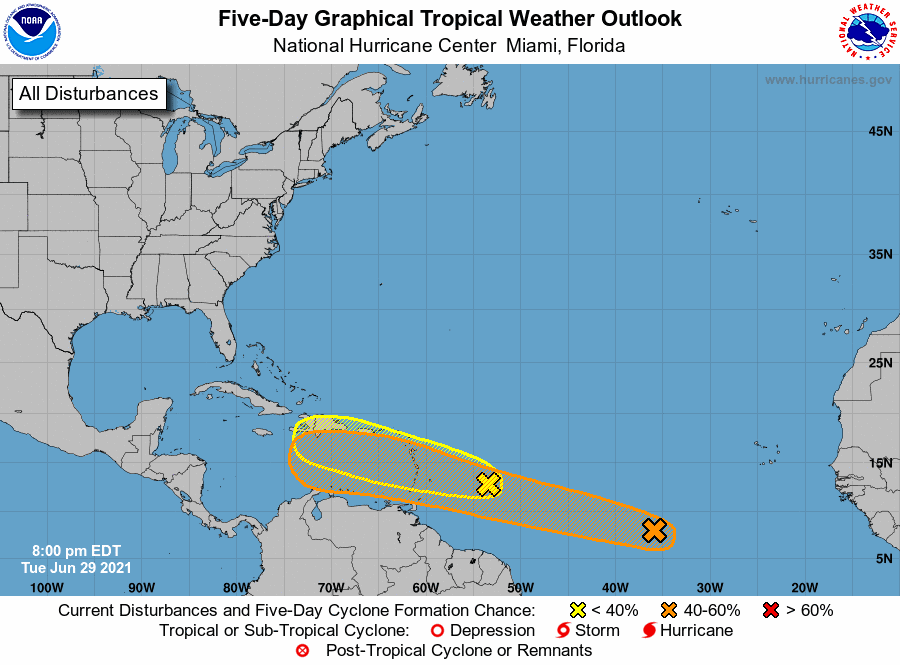
While the development chances for one Atlantic Ocean disturbance have lessened, forecasters said another system could form into a tropical depression in a handful of days, according to the National Hurricane Center's 7 p.m. update Tuesday.
Both systems are moving west toward the Caribbean, but it's too early to tell if either system could enter the Gulf of Mexico.
Increased formation chances for disturbance
An area of low pressure between Africa's west coast and the Winward Islands now has a 60% chance of becoming a tropical depression in the next five days, a significant jump from Tuesday morning when forecasters had development chances at 20%.
Forecasters said the system is showing signs of better organization as it moves west northwest at 20 mph. The storm should reach the area near Winward and Leeward Islands by Friday, NHC said.
The shaded area on the graphic is where a storm could develop and is not a track. The National Hurricane Center releases a track when a tropical depression forms or is about to form.
The categories, in order of increasing strength, are tropical depression, tropical storm and hurricane (categories 1 through 5). Systems are named when they develop into a tropical storm.
Second disturbance in Atlantic
Unlike the system following closely behind it, this disorganized system's 5-day formation chances lessened to 20% on Tuesday evening. It was at 40% Tuesday morning.
The tropical wave is a few hundred miles east of the Lesser Antilles and moving quickly west and west northwest at up to 25 mph. It is expected to pass over the Lesser Antilles by Wednesday before it reaches the eastern and central Caribbean later in the week.
Forecasters said they expect development of the system to be slow but said it will be heavy rains to the Lesser Antilles.: https://www.nola.com/news/hurricane/...f37788791.htmlLeave a comment:
-
Tropical Storm Danny forms off coast of South Carolina

The fourth tropical storm of 2021, Tropical Storm Danny, formed off the coast of South Carolina Monday afternoon, according to the National Hurricane Center.
Why it matters: Tropical Storm Danny's arrival in June signals the season is off to an active start. On average, the fourth named storm arrives each year on Aug. 23.
The big picture: Danny is expected to make landfall later Monday, the National Weather Service forecast office in Columbia, South Carolina, said.
A Lake Wind Advisory has been issued for much of the state.
The storm has maximum sustained winds of about 40 mph, per the National Hurricane Center.
Residents of South Carolina and Georgia "should prepare for gusty winds, up to 3 inches of rain and minor storm surge," per ABC News.: https://www.axios.com/tropical-storm...bbfee5c3f.htmlLeave a comment:
-
Season's first eastern Pacific hurricane forms off Mexico

The first hurricane of the eastern Pacific season has formed and forecasters say it may grow a bit stronger while advancing northwestward off the Mexican coast, potentially causing heavy rainfall on shore.
The U.S. National Hurricane Center said Hurricane Enrique’s maximum sustained winds strengthened in its first hours but were holding near 85 mph Saturday evening.
Earlier forecasts said Enrique could reach Category 2 strength by Sunday, but the center says the latest conditions pointed to only some slight further gain in power.
The storm’s core is predicted to stay at sea while moving parallel to the coast.
But a tropical storm warning has been declared from Zihuatanejo to Cabo Corrientes and forecasters warn of 6 to 12 inches of rain.: https://www.10news.com/weather/weath...rms-off-mexico
Leave a comment:
-
12 dead in Alabama due to Claudette, including 9 children in multi-vehicle crash; storm to strengthen on way to East Coast
Tropical Depression Claudette left at least 12 dead in Alabama, battering and flooding parts of the U.S. Southeast as it moved toward the Atlantic Coast.
The storm was predicted to restrengthen Sunday night, according to the National Hurricane Center, becoming a tropical storm late Sunday or Monday over eastern North Carolina. It's expected to become a post-tropical cyclone Tuesday.
The storm is forecast to produce additional rainfall totals of 2 to 4 inches, with isolated highs of up to 6 inches, across the eastern portions of the Florida Panhandle into North Florida, southern Georgia, central and coastal South Carolina into eastern North Carolina through Monday morning, the hurricane center said.
Tropical storm warnings and watches were in place for both Carolinas from Monday afternoon to Tuesday morning, the weather service said. Heavy rainfall and gusty winds are forecast for the states.
Ten people, including nine children, died in a multi-vehicle collision Saturday that was probably caused by storm-related hydroplaning, Butler County Coroner Wayne Garlock said. Garlock did not respond to a voicemail left Sunday.
The National Transportation Safety Board is investigating the crash, and an investigator is expected to be at the pileup location Sunday night, spokesman Keith Holloway said. Ten NTSB investigators will coordinate with the Alabama Highway Patrol.
Tallapoosa County Girls Ranch, south of Montgomery, confirmed that one of its vehicles was involved in the crash. The program is part of the nonprofit Alabama Sheriffs Youth Ranches, which provide homes for needy, neglected or abused school-age children.
"Please send prayers our way as we navigate this difficult time," the Tallapoosa ranch said in a Facebook post.
A website for the ranch shows the children attend Reeltown School. A Facebook post for the high school said it planned to offer counseling support and a prayer session Sunday afternoon.
The crash occurred on Interstate 65 at around 2:30 p.m. Saturday in Butler County, south of Montgomery. The wreck blocked traffic in both directions for most of the day.
Butler County Sheriff Danny Bond told the Montgomery Advertiser, part of the USA TODAY Network, that the "horrific scene" was the worst traffic accident he'd ever witnessed. He said the tragedy involved 18 vehicles and caused multiple injuries.
NTSB investigations typically involve close examination of accident sites and efforts to reconstruct the circumstances. The investigations often continue for months before the likely cause is identified and made public.
A 24-year-old father and his 3-year-old son died in their home when a falling tree struck the residence, Capt. Marty Sellers of the Tuscaloosa County Sheriff's Office told the Tuscaloosa News.
In a Facebook post, Tuscaloosa City Council President Kip Tyner confirmed the father-and-son deaths and said more than 7 inches of rain produced widespread flooding, evacuations and trapped motorists.: https://www.usatoday.com/story/news/...ma/7762373002/
Leave a comment:
-
7 million along US Gulf Coast are under a tropical storm warning, with landfall expected Friday night
A tropical storm is expected to form in the Gulf of Mexico on Friday, putting 7 million Americans under warnings for heavy winds and rain.
Maximum sustained winds with the system increased Friday from 35 to 45 mph as the system moved generally northward towards the US Gulf Coast.
Despite having sustained winds supportive of a tropical storm, the system remains disorganized without a center of circulation required to be a named storm.
After it forms and gains the official name Claudette, the storm will hit the Louisiana coastline Friday night, according to the National Hurricane Center's latest update.
"Landfall is expected later tonight, with the center moving near or over New Orleans on Saturday morning," said CNN meteorologist Dave Hennen.
By 11 a.m. EST Friday, heavy rainfall and wind gusts were beginning to reach portions of the northern Gulf Coast, the center said. Tropical storm-force winds can be felt as far as 205 miles from the center of the disturbance, forecasters added.
Grand Isle, Louisiana, measured sustained winds at 40 mph.
Louisiana, hit hard by heavy rain and flooding last month, is under a state of emergency.
The storm is forecast to hit Alabama, Mississippi, Georgia, Louisiana and the Florida Panhandle through the weekend, according to CNN meteorologist Robert Shackelford.
Tropical storm warnings extend from Louisiana into the Florida Panhandle, affecting cities like New Orleans; Gulfport and Biloxi, Mississippi; Mobile, Alabama; and Pensacola, Florida.
Most of the heavy rain and wind will be east of where the center hits land. So eastern Louisiana, Alabama and Georgia will bear the worst of the storm, forecasters say.
And some areas of the coast could see up to 3 feet of storm surge.
Widespread flash flooding will be the main threat in the Southeast.: https://www.cnn.com/2021/06/18/weath...day/index.html
Leave a comment:
-
Tropical system to bring heavy rain, flooding to Gulf Coast
MIAMI (AP) — Forecasters predict a tropical system will bring heavy rain, storm surge and coastal flooding to the northern Gulf Coast as early as Friday and throughout the weekend.
A tropical storm warning was already in effect for parts of Louisiana, Mississippi and Alabama — extending from Intracoastal City, Louisiana, to the Alabama-Florida border, according to the National Hurricane Center in Miami.
The poorly-organized disturbance was located early Friday about 390 miles (630 kilometers) south of Morgan City, Louisiana, with maximum sustained winds of 35 mph (55 kph). It was moving north at 9 mph (15 kph).
Louisiana Gov. John Bel Edwards late Thursday issued a state of emergency due to the potential weather threats. The move is an administrative step that authorizes the use of state resources to aid in storm response efforts, the governor’s office said.
The system is expected to produce up to 8 inches (20 centimeters) of rain across the Yucatán Peninsula of Mexico, and up to 12 inches (30 centimeters) through the weekend from the central U.S. Gulf Coast northeastward into the Southern Appalachians.
The combination of storm surge and the tide will cause normally dry areas near the coast to be flooded by rising waters moving inland from the shoreline, the hurricane center said. The water could reach the heights of about 1-3 feet (30-91 centimeters).
There have already been two named storms during the 2021 Atlantic hurricane season. Meteorologists expect the season to be busy, but not as crazy as the record-breaking 2020 season.: https://news.yahoo.com/tropical-syst...061039041.html
Leave a comment:
-
Claudette is likely to form and make landfall in the US this week, delivering close to a foot of rainfall
The US will likely be hit by the first tropical system of the season by the end of this week, bringing nearly a foot of rain to parts of an already drenched South.
The system is currently stationed over the Bay of Campeche in the Gulf of Mexico and southern Mexico as a collection of disorganized showers and thunderstorms.
The National Hurricane Center (NHC) puts the chance of tropical development within the next 48 hours at 70%, and a 90% chance within the next five days in the Gulf.
If the disturbance strengthens according to forecasts, it will be named Claudette -- the third named storm of the 2021 season.
Uncertainty is high regarding the track of the storm since it has not formed yet, but current forecasts have the system reaching the northern Gulf Coast this weekend. Landfall is possible from the Texas coast to Florida.
"A tropical depression is likely to form by late Thursday or on Friday when the low moves across the western Gulf of Mexico," the NHC said in its discussion.
Current model guidance is indicating that the storm will track toward the western Gulf Coast, near Texas and Louisiana. There is considerable uncertainty in the tracks, but if this scenario plays out, areas vulnerable to flooding could see the greatest impacts of the system.: https://www.cnn.com/2021/06/16/weath...all/index.html
Leave a comment:
-
Hurricane center monitoring system likely to become 3rd tropical depression; Bill fizzles out
The second named storm of the 2021 season, Bill, fizzled out of the National Hurricane Center’s radar Tuesday. Meanwhile, the NHC is watching a system in the Gulf of Mexico that is likely to become the next tropical depression by Thursday.
A broad low-pressure area associated with disorganized showers and thunderstorms is pummeling the southern tip of Mexico, according to the NHC’s 2 a.m. update. The system is forecast to make very little movement throughout Wednesday and go through slow development due to interaction with the land, the NHC said.
However, as the system begins to move northward Thursday, it is likely to become the third tropical depression of the year; likely sometime either Thursday or Friday. Regardless of development, the broad area of pressure is expected to continue dumping rain over Central America and southern Mexico, the NHC said.
The low has a 60% chance of becoming either a tropical depression or storm in the next 48 hours and a 90% chance of doing so in the next five days.
If it grows strong enough into a tropical storm, it will be the third named storm of the year and receive the title, Claudette.
In order to do so, it would need to develop a closed circulation and its maximum sustained winds would need to be stronger than 39 mph.: https://www.orlandosentinel.com/weat...7qe-story.html
Leave a comment:
-
Tropical Storm Bill Forms Off the East Coast
Hundreds of miles off the coast of North Carolina, Tropical Storm Bill was upgraded from a tropical depression late Monday night, becoming the second named storm of the Atlantic hurricane season, the National Hurricane Center said.
The weather system was expected to remain away from the coast and was forecast to be “short-lived.”
By early Tuesday morning, Tropical Storm Bill was about 240 miles southeast of Nantucket, Mass., with maximum sustained winds of 50 miles per hour, the Hurricane Center said.
Later in the morning, the Hurricane Center said Bill was “racing northeastward,” with maximum sustained winds of 60 m.p.h. It was expected to become an “extratropical” storm later on Tuesday, meaning that it was not expected to quickly develop into a hurricane.
A Category 1 hurricane has wind speeds beginning at 74 m.p.h.
While there were no coastal watches or warnings in effect, the storm was moving northeast at 38 miles per hour and was expected to continue on this track through Wednesday with increasing forward speed, the Hurricane Center said.
Some additional strengthening was possible for Tuesday, but the storm was expected to become a post-tropical low and dissipate on Wednesday.
Meteorologists were also watching a weather disturbance in the Gulf of Mexico. It was producing showers and thunderstorms over the Bay of Campeche, just west of the Yucatán Peninsula. That system was expected to move northward and possibly form into a tropical depression by the end of the week, bringing heavy rains to the northern Gulf Coast.
A second disturbance, described as a tropical wave, was reported hundreds of miles south of the Cabo Verde Islands.
In late May, the Atlantic Ocean recorded its first named storm of the hurricane season. Ana, a subtropical storm, developed northeast of Bermuda. It was the seventh year in a row that a named storm developed in the Atlantic before the official start of the season on June 1.
Scientists with the National Oceanic and Atmospheric Administration forecast that there would be 13 to 20 named storms this year, six to 10 of which would be hurricanes, and three to five major hurricanes of Category 3 or higher in the Atlantic.: https://www.nytimes.com/article/trop...hurricane.html
Leave a comment:

Leave a comment: