Announcement

Collapse
No announcement yet.

Storms

Collapse
X
 
  • Filter
  • Time
  • Show
Clear All
new posts

  • 'The climate crisis is here' declares Biden as US is ravaged in one week by hurricane, floods and wildfires

    President Biden on Thursday declared the “climate crisis” is here as Hurricane Ida devastated Northeastern and Gulf states this week and record wildfires continue to tear through the West.

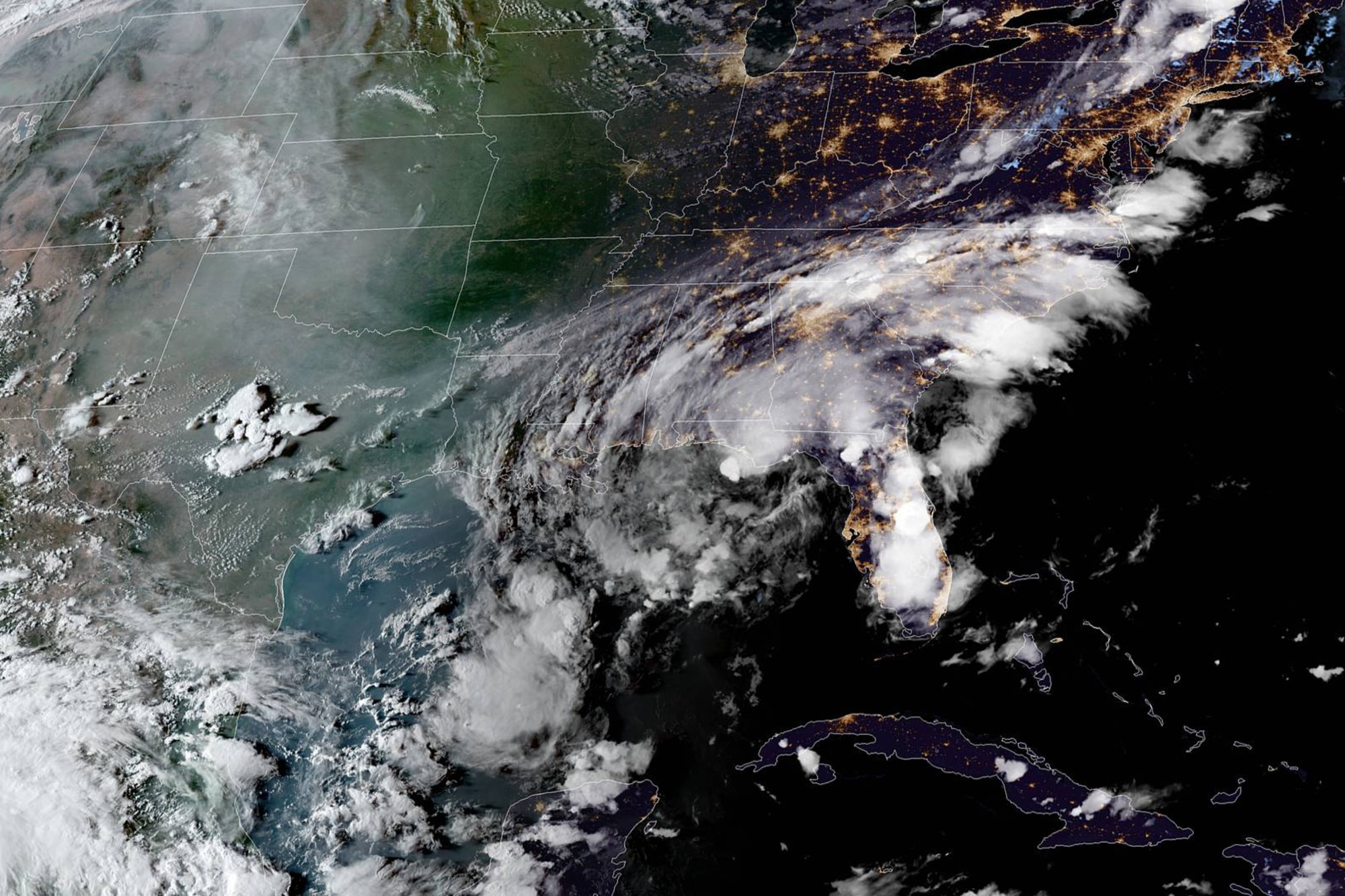
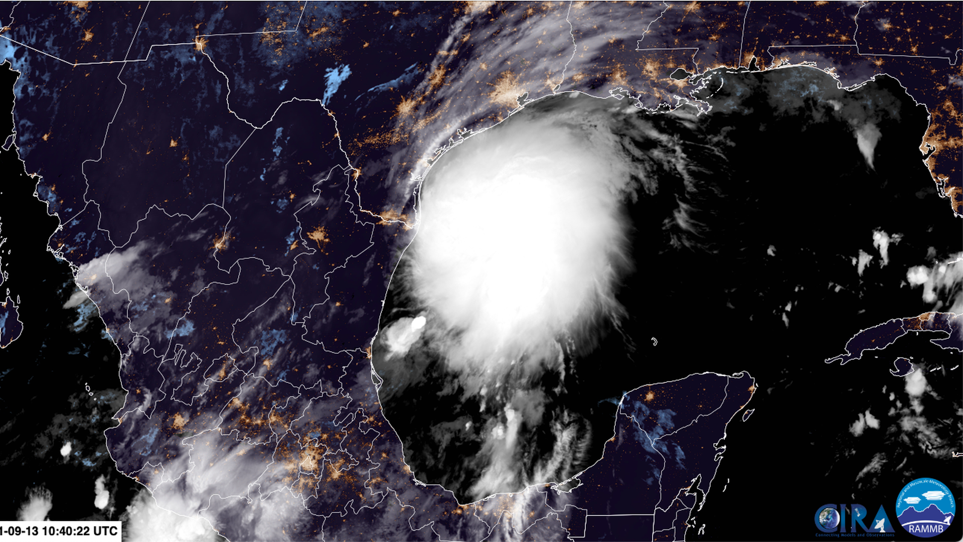
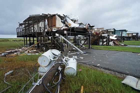
    Ida made landfall in Louisiana Sunday as a Category 4 hurricane, slamming the region with sustained winds of 150 miles per hour. Ida tied the Last Island Hurricane in 1856 and Hurricane Laura in 2020 as the strongest to make landfall in the state, according to The Washington Post.

    The hurricane left millions in Louisiana and Mississippi without power, and Biden noted the storm was so powerful it caused the Mississippi river to temporarily change directions.

    But the remnants of Ida went on to unleash dangerous flash floods as it swept through the East Coast days later. The unprecedented flooding left at least 43 people dead across New York, New Jersey, Pennsylvania and Connecticut.

    “The past few days of Hurricane Ida and the wildfires in the west, and the unprecedented flash floods in New York and New Jersey, is yet another reminder that these extreme storms and the climate crisis are here,” Biden said during a news conference.

    “We need to be much better prepared. We need to act,” he said.

    Biden said he will press Congress to pass his nearly $1 trillion infrastructure bill to provide “historic investments” to modernize roads, bridges, the electric grid and sewer and draining systems.

    “We’re reminded that this isn’t about politics. Hurricane Ida didn’t care if you were a Democrat or a Republican, rural or urban. It’s destruction is everywhere. It’s a matter of life and death and we’re all in this together.”

    Meanwhile, the president this week approved an emergency declaration for California as crews work around the clock to tame the Caldor Fire.

    Tens of thousands of people in the Lake Tahoe area have been forced to evacuate as the fire has closed in on the scenic mountain getaway.

    The fire has burned more than 212,000 acres and is just 29 percent contained.:
    https://thehill.com/changing-america...lares-biden-as

    I think the death toll is up to 49 now: https://www.nbcnews.com/news/weather...coast-n1278457
    Keep your friends close and your enemies closer

    Comment


    • New Orleans mayor to evacuated residents: 'You can come home'

      New Orleans Mayor LaToya Cantrell (D) told residents who were evacuated due to Hurricane Ida that they could return home.

      In a news conference Friday, Cantrell struck an optimistic tone as power is being restored to the city, with nearly all electricity expected to be returned next week.

      “What we have been saying and really saying more aggressively today to those residents who did evacuate and as they see power restored to their communities into their neighborhoods — we are saying you can come home,” Cantrell said.

      Cantrell added that as residents come home, they could “free up the burdens that some of our residents have as they go without power.”

      Cantrell made the comments as recovery efforts in the city entered the fifth day, after Hurricane Ida made landfall along the U.S. Gulf Coast on Sunday. The storm, which made landfall on the 16th anniversary of Hurricane Katrina, flooded parts of the state and left millions without power for days.

      Some power has been restored to the city since the storm, and Entergy, the utility company that services New Orleans and southeastern portions of Louisiana, has said most of the city will have power by next Wednesday. However, this is subject to change.

      Cantrell said she was “cautiously optimistic” that power would be restored by then.: https://thehill.com/homenews/state-w...-can-come-home
      Keep your friends close and your enemies closer

      Comment


      • Scientists detail role of climate change in Ida's intensity

        A combination of climate-related factors such as warm ocean temperatures and increased sea level rise helped fuel Hurricane Ida and its path of destruction, scientists said.

        The deadly storm made landfall as a Category 4 hurricane on Sunday, hitting Louisiana and Mississippi and leaving more than 1 million people without power as of Monday morning.

        According to a recent United Nations report on climate change, hurricanes like Ida are likely to continue to intensify as the planet keeps warming.

        Jonathan Overpeck, a climate scientist and dean of the University of Michigan’s School for Environment and Sustainability, told The Hill that the warm ocean temperatures in the Gulf of Mexico appeared to cause Ida to strengthen in such a short amount of time.

        “Those warm ocean temperatures are the fuel for these big tropical storms. So with Ida you saw it intensify rapidly to a Category 4 storm, and that’s a real classic climate change signal,” Overpeck said.

        Ocean heat causes evaporation, he said, and that plays a major role in how storms form and their level of intensity. Two other factors are precipitation brought by a warmer atmosphere and storm surge exacerbated by rising sea levels.

        “I would be willing to bet money that once the ... research is done, it will become clear that this storm was supercharged by climate change in all three ways,” said Overpeck.

        Those factors are part of a larger pattern, said John Nielsen-Gammon, a professor at Texas A&M University and climatologist for the state of Texas.

        “We can’t tell with one hurricane, but the records show that — in the Atlantic basin at least — major hurricanes have become more common, rapid intensification has become more common, intense rain from hurricanes has become heavier and the sea level has risen, which makes storm surges higher,” Nielsen-Gammon said.: https://thehill.com/policy/energy-en...idas-intensity

        Keep your friends close and your enemies closer

        Comment


        • More than 400K without power nine days after Ida hits Louisiana

          More than 400,000 people are still without power nine days after Hurricane Ida hit Louisiana.

          As of Tuesday afternoon, 412,759 people were without power, according to numbers from PowerOutage.US.

          Ida made landfall on Aug. 29 and left more than 1 million people without power in Louisiana. The Louisiana Department of Health confirmed Tuesday that the death toll in the state is now at 15.


          Entergy, one of the utilities that provides power in Louisiana and Mississippi, said Tuesday that it has restored power to 60 percent of its 948,000 customers in both states that lost power, or about 571,000 customers.

          This includes 54 percent of its customers who lost power in Louisiana and all of its customers who lost power in Mississippi.

          Entergy said that for some of the communities that were hit hardest by the storm, power should be restored no later than Sept. 29, though estimates are subject to change.: https://thehill.com/policy/energy-en...hits-louisiana

          Hurricane Ida death toll rises past 60: https://www.axios.com/hurricane-ida-...405ae0fa1.html

          Keep your friends close and your enemies closer

          Comment


          • Rapidly-intensifying Typhoon Chanthu headed for Taiwan and southern China


            A typhoon headed toward Taiwan and the southern coast of China is rapidly gaining in speed and strength ahead of an expected landfall later this week.

            Typhoon Chanthu has rapidly intensified in the past 36 hours from a tropical depression into a severe typhoon, according to the Joint Typhoon Warning Center, with maximum wind speeds of up to 233 kilometers per hour (145 miles per hour). It is likely Chanthu will expand into a super typhoon in the coming hours.

            Given the trajectory of the storm, it is still unclear whether Chanthu will first pass over Taiwan before it slams into southern China or narrowly miss the island. Either way, at its current pace, the storm is estimated to make landfall on either Saturday or Sunday.

            Typhoon Chanthu is just one of two dangerous weather systems which are barreling across the western Pacific. Severe Tropical Storm Conson made landfall in the Philippines overnight on Monday and will pass over the country before it heads north towards China's Hainan Island.

            Conson is seeing wind speeds of up to 112 kph (70 mph). According to CNN Philippines, while warning signals were hoisted across the storm's path, no major damage has been reported so far.

            Chanthu is likely to be the strongest storm to hit Taiwan or mainland China since Typhoon In-fa in July, which worsened already severe flooding across China's southeast.

            In total, the economic losses from the typhoon and the flooding came to more than $14 billion, according to Chinese state-run media.: https://www.cnn.com/2021/09/08/asia/...hnk/index.html - https://mb.com.ph/2021/09/08/tropica...-kiko-tracker/

            Keep your friends close and your enemies closer

            Comment


            • Chanthu rapidly intensifies into 2nd super typhoon of 2021


              AccuWeather forecasters say the West Pacific basin continues to remain active as Typhoon Chanthu exploded in intensity over the open waters of the Philippine Sea on Wednesday and became just the second super typhoon of 2021.

              The Joint Typhoon Warning Center (JTWC) designated Chanthu as a super typhoon based on its one-minute average sustained wind speed. The first storm of the season to achieve super typhoon status was Super Typhoon Surigae, which roared to life in mid-April.

              As of Wednesday evening, local time, Chanthu was located over the open waters of the Philippine Sea and was tracking to the west-southwest at a speed of 12 mph (20 km/h), according to the Japanese Meteorological Agency (JMA). Chanthu's 10-minute average sustained winds were 110 mph (178 km/h), meaning it was the equivalent of a strong Category 3 hurricane on the Saffir-Simpson Hurricane Wind Scale.

              Chanthu had developed a clear eye on satellite imagery on Wednesday, further indicating just how powerful the storm had become.

              Due to favorable conditions for development in the Philippine Sea, Chanthu was able to undergo rapid intensification Tuesday into Wednesday. Rapid intensification is defined as a tropical system gaining 30 knots (35 mph or 55 km/h) of sustained wind speed in 24 hours or less. Chanthu met the criteria by more than double, gaining 75 knots of wind intensity in just 24 hours, according to the JTWC.: https://news.yahoo.com/chanthu-rapid...173530282.html - https://gcaptain.com/super-typhoon-c...stern-pacific/

              Typhoon Jolina leaves 9 dead, 9 missing: https://newsinfo.inquirer.net/148547...dead-9-missing


              Keep your friends close and your enemies closer

              Comment


              • Tropical Storm Mindy makes landfall in Florida Panhandle

                Mindy, the 13th named storm of the Atlantic hurricane season, could bring up to 6 inches of rain in some spots.


                Hours after Tropical Storm Mindy formed off the Florida Panhandle on Wednesday, it made landfall with 45-mph winds and a potential for up to 6 inches of rain, forecasters said.

                The center of the storm made landfall near St. Vincent Island, southwest of Tallahassee, around 9:15 p.m. ET, the National Hurricane Center said. It was moving northeast at 21 mph.

                Tropical storm warnings were in place for a stretch of the Florida coast from Mexico Beach to the Steinhatchee River.

                Mindy is the 13th named storm of the Atlantic hurricane season. It formed in the Gulf of Mexico at around 5 p.m.

                Mindy is forecast to cross the Florida Panhandle on Wednesday night and sweep across the state and southern Georgia. The center should be in the Atlantic Ocean on Thursday, forecasters said.

                The storm is expected to bring 2 to 4 inches of rain, but up to 6 inches is possible in spots, the hurricane center said.: https://www.nbcnews.com/news/weather...andle-n1278746

                Keep your friends close and your enemies closer

                Comment


                • Typhoon Chanthu weakens towards Taiwan


                  Taiwan has downgraded Typhoon Chanthu to a medium typhoon, saying that while it will bring heavy rain and gusting winds to most of the island it is unlikely to make direct landfall.

                  Taiwan's Central Weather Bureau on Saturday said the storm, which was at one point categorised a super typhoon, was losing strength as it headed up the Bashi Channel that separates Taiwan from the Philippines.

                  It forecast Chanthu would skirt Taiwan's sparsely populated and mountainous east coast on Saturday night and into Sunday morning, then head towards China's Zhejiang province and Shanghai.

                  Taiwanese airlines cancelled their Saturday afternoon domestic flights, though there was only limited impact on international services.

                  The typhoon is unlikely to affect Taiwan's globally important semiconductor factories on its west coast, plants busy ramping up output to alleviate a global shortage of chips that has hit car makers especially hard.

                  Still, the government has ordered disaster preparations in case of landslides or flooding.

                  At the northeast coast port of Nanfangao, fishing boats crowded into the harbour to escape the coming storm.

                  In 2009, typhoon Morakot killed about 700 people in Taiwan, the deadliest storm to ever hit the island.

                  Subtropical Taiwan relies on the typhoon season to replenish its reservoirs, but after none hit the island last year water levels dropped drastically, leading to Taiwan's worst drought in history and widespread water restrictions.

                  The drought ended after heavy rainfall in the late spring and early summer.: https://www.areanews.com.au/story/74...aiwan/?cs=9352 - https://www.ssd.noaa.gov/jma/wpac/h5-loop-rb.html

                  Keep your friends close and your enemies closer

                  Comment


                  • Powerful Typhoon Chanthu Hitting Taiwan, Shanghai Next

                    Typhoon Chanthu in the Western Pacific is moving over Taiwan. It is then expected to move towards Shanghai where is is forecast to bring several inches of rain.: https://weather.com/storms/hurricane...wan-china-next


                    Keep your friends close and your enemies closer

                    Comment


                    • Typhoon Chanthu drenches Taiwan but spares island a direct hit

                      Typhoon Chanthu unleashed powerful winds and heavy rain on eastern Taiwan on Sunday (Sep 13), disrupting travel links and cutting electricity to some homes but sparing the island a direct hit.

                      Downgraded from a super typhoon since its rapid formation last week, the outer edges of Chanthu pounded the eastern coastline.

                      But the centre of the storm remained out to sea as it moved north, the central weather bureau said.

                      The eastern regions of Hualien and Taitung have received around 200mm of rain so far, the bureau added.

                      Waves of up to 7m were recorded on Orchid Island off Taiwan's eastern coast.

                      A total of 159 flights have been cancelled due to the typhoon, the central emergency operation centre said. All ferry services to offshore islands were also suspended, along with some train routes.

                      Around 26,000 households have lost power, authorities added.

                      "The typhoon is pretty solid and its impact is most obvious today bringing strong winds, rains and waves before it gradually moves away tomorrow," said forecaster Hsu Chung-yi.

                      At 10am, Chanthu was 90km northeast of Hualien, packing gusts of up to 198kmh, the bureau said.

                      Most businesses and public venues were closed in eastern and parts of northern Taiwan, including the capital Taipei where heavy rains started on Sunday.

                      Around 2,600 people in landslide-prone areas around Hualien have been evacuated while some 31,000 troops are on standby for relief work.

                      Taiwan is regularly hit by tropical storms in the summer months.

                      In a rare exception to the rule, not a single typhoon made landfall last year, the first time in 56 years.

                      That helped fuel the worst drought in decades until heavy rains set in a few months ago and brought needed relief.: https://www.channelnewsasia.com/asia...ct-hit-2172246

                      Keep your friends close and your enemies closer

                      Comment


                      • Texas, Louisiana brace for heavy rain as Tropical Storm Nicholas nears Gulf Coast


                        Tropical Storm Nicholas strengthened as it neared the Gulf Coast Monday — threatening to bring heavy rains and "potentially life-threatening" flash flooding to Mexico, Texas and hurricane-devastated Louisiana.

                        Threat level: The storm is forecast to reach the middle Texas coast as a strong tropical storm on Monday, and could reach near-hurricane intensity at landfall, per the National Hurricane Center.

                        The NHC warned of "life-threatening storm surge inundation" along the coast of Texas from Port Aransas to Sabine Pass.

                        What's happening: Gov. John Bel Edwards (D) declared a state of emergency late Sunday for Louisiana, which is still reeling from last month's deadly Hurricane Ida.

                        Texas Gov. Greg Abbott (R) tweeted on Sunday night that the state had begun mobilizing resources due to Nicholas' threat of heavy rains, winds and the potential for flooding, adding: "Heed warnings from local officials and be sure to avoid high water."

                        Our thought bubble, via Axios' Andrew Freedman: This slow-moving storm poses a serious flood risk to coastal areas of Texas and, subsequently, Louisiana.

                        Nicholas' slow movement will allow copious amounts of Gulf moisture to flow inland.

                        Studies show tropical storms and hurricanes are dropping more rain as the climate warms due to human activities.

                        State of play: The storm had maximum sustained winds of 60 mph as it moved some 45 miles northeast of the mouth of the Rio Grande at 11 a.m. ET, per the latest NHC advisory.: https://www.axios.com/tropical-storm...6fe2ac0c8.html


                        Keep your friends close and your enemies closer

                        Comment


                        • Huge alligator suspected of killing man in Ida floodwaters caught with human remains in stomach

                          The St. Tammany Parish Sheriff’s Office said the 12-foot-long alligator weighing a staggering 504 pounds was captured near the New Orleans suburb of Slidell and killed Monday.

                          Authorities say they found what appears to be human remains inside the animal's stomach and investigators are working to determine if they were those of 71-year-old Timothy Satterlee Sr.

                          Satterlee was attacked by an alligator in floodwaters outside his home on Aug. 30 a day after Ida devastated the region.

                          According to The Associated Press, Satterlee’s wife witnessed the attack but managed to pull her injured husband to the steps of the home. She then used a boat to reach higher ground to get help, but when she returned Satterlee was missing.

                          Authorities for the past several weeks have been combing the area for any sign of Satterlee or the gator that attacked him, and finally spotted the animal over the weekend in a waterway near where the attack happened.

                          Sheriff’s deputies and wildlife officials set traps and managed to wrangle the gator.

                          “This is a horrible tragedy and my sincere condolences and sympathy goes to the Satterlee family,” St. Tammany Sheriff Randy Smith said in a statement.

                          “I know today's findings does not bring their loved one back, but hopefully this can bring them some sort of closure. I am very proud of the hard, non-stop work of my deputies and the other agencies who assisted, and I hope their persistence in finding this alligator will help the family coping with their loss,” Smith said.: https://thehill.com/changing-america...ing-man-in-ida

                          Keep your friends close and your enemies closer

                          Comment


                          • Rare "high-risk" flash flood alert issued as Nicholas nears Louisiana

                            Southwest Louisiana faces a "high risk" of flash flooding from Tropical Depression Nicholas on Wednesday morning, the National Weather Service warned.

                            Why it matters: Such "high risk" outlooks are rarely issued anywhere in the U.S. There's also a medium risk of flash-flooding in New Orleans, which is still reeling from Hurricane Ida striking the state last month.

                            "Life-threatening" flash floods are also expected for other parts of the Deep South, per the National Hurricane Center.

                            Our thought bubble: The alert is due to the former hurricane slowing down its forward movement. As the bands of rain work east, they're moving into ground more saturated in the wake of Ida — which raises the risk of flash flooding in the rest of Louisiana as well as parts of Mississippi.

                            Threat level: Rain from the slow-moving storm was expected to produce 5 to 10 inches of rainfall across parts of southern and central Louisiana, southern Mississippi, far southern Alabama, and the western Florida Panhandle through early Friday, the NHC said late Tuesday.

                            Isolated storm totals of 20 inches were possible from southern Louisiana to the far western Florida Panhandle.

                            "Life-threatening flash flooding impacts, especially in urban areas, are possible across these regions," the NHC warned.

                            By the numbers: More than 125,000 customers were without power in Texas and over 75,000 others in Louisiana had no electricity on Wednesday morning, according to the utility tracking site poweroutage.us.

                            The big picture: Nicholas made landfall near Sargent Beach, Texas, as a Category 1 hurricane early on Tuesday.

                            It later weakened to a tropical depression, but continued to dump heavy rains on the Houston metro area as it slowly moved its way over southeastern Texas and southwestern Louisiana.

                            https://www.axios.com/rare-high-risk...e4cf7b16c.html
                            Keep your friends close and your enemies closer

                            Comment


                            • Tropical Depression Nicholas stalls over storm-battered Louisiana

                              Tropical Depression Nicholas lingered Wednesday over a storm-battered Louisiana, threatening to drop heavy rains on a still-recovering state.

                              Nicholas made landfall as a hurricane early Tuesday on the Texas coast, dumping dangerous amounts of rain even though it was quickly downgraded to a tropical storm and later a depression.

                              Galveston, Texas, recorded nearly 14 inches of rain from Nicholas, the 14th named storm of the 2021 Atlantic hurricane season. More than 100,000 customers in the state were still without power Wednesday.

                              The depression, now 30 miles northeast of Lake Charles Louisiana, is expected to drop 3 to 6 more inches of rain across the central Gulf Coast, with up to 10 inches in some areas, according to the National Hurricane Center.

                              Life-threatening flash flooding is possible through Friday in central to southeastern Louisiana, southern Mississippi, southern Alabama and the Florida Panhandle. Tornadoes were also possible in those states Wednesday.

                              Louisiana was still cleaning up from Ida, which made landfall as a powerful Category 4 hurricane and battered the southeast portion of the state on Aug. 29.

                              Louisiana Gov. John Bel Edwards said Nicholas will complicate an already difficult recovery from Ida.


                              He noted that 95,000 electric customers were still without power more than two weeks after Ida hit. And he said the new storm could mean some who had regained power might lose it again. Homes already badly damaged by Ida were not yet repaired to the extent that they could withstand heavy rain, Edwards added.: https://www.nbcnews.com/news/weather...siana-n1279266
                              Keep your friends close and your enemies closer

                              Comment


                              • Typhoon Chanthu to make landfall Sept. 17, heavy rain predicted


                                Japan's weather agency warned Thursday that a typhoon set to make landfall in the western part of the country Friday afternoon could bring heavy rain and cause landslides and flooding.

                                Typhoon Chanthu, this year's 14th typhoon, is forecast to move from the East China Sea to the Tsushima Strait on Friday before crossing from western to eastern Japan over the weekend, the Japan Meteorological Agency said.

                                The agency previously forecast that the typhoon would turn into an extratropical cyclone before approaching the southwestern main island of Kyushu.

                                JR West said it will suspend most shinkansen services between Hiroshima and Kyushu, and some bullet trains between Hiroshima and Shin-Osaka on Friday.

                                Western Japan is now expected to be hit by strong winds on Friday, with torrential rainfall forecast for Thursday night through Friday. The typhoon is predicted to become an extratropical cyclone, bringing strong winds and heavy rain to parts of western Japan to northern Japan on Saturday.

                                As of 6 p.m., the typhoon was located around 330 kilometers west-southwest of Goto, Nagasaki Prefecture, heading north-northeast at a speed of about 15 kilometers per hour. It had an atmospheric pressure of 990 hectopascals at its center, with a maximum gusts of 126 kph, according to the agency.

                                In the 24 hours through 5 p.m. Friday, rainfall of up to 250 millimeters is forecast for northern Kyushu, up to 200 mm for Shikoku and up to 150 mm in southern Kyushu.: https://english.kyodonews.net/news/2...predicted.html

                                Keep your friends close and your enemies closer

                                Comment

                                Valentina Jewels gets pounded like a btich dog ?????? ??????? ????????? ???????? ???? diferentes tipos de bajinas
                                antalya escort bayan
                                Working...
                                X